Geolocate

Samobor topographic map

Click on the map to display elevation.

About this map

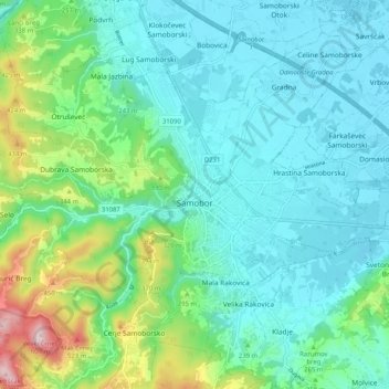
Name: Samobor topographic map, elevation, terrain.

Location: Samobor, Grad Samobor, Zagreb County, Croatia (45.78078 15.65733 45.82596 15.75969)

Average elevation: 735 ft

Minimum elevation: 407 ft

Maximum elevation: 1,936 ft

Other topographic maps

Click on a map to view its topography, its elevation and its terrain.

Pokupsko

Croatia > Zagreb County

Average elevation: 436 ft

Dane

Croatia > Zagreb County

Average elevation: 2,011 ft

Turki

Croatia > Zagreb County > Kupljenovo

Average elevation: 518 ft

Kloštar Ivanić

Croatia > Zagreb County

Average elevation: 433 ft

Novi dvori

Croatia > Zagreb County > Zaprešić

Average elevation: 433 ft

Konšćica

Croatia > Zagreb County

Average elevation: 866 ft

Gear up for your next adventure:

🏔️Mountain Trail Maps - High‑detail maps for popular peaks
🛏️Cold Weather Sleeping Bag - Warm sleeping bag for cold conditions
🔋Rechargeable Batteries - Power up your outdoor devices
Camping Coffee Makers - Enjoy premium coffee at the summit or campsite
🥄Camping Utensil Set - Lightweight utensils for outdoor meals

As an Amazon Associate, this site earns from qualifying purchases at no extra cost to you.