Geolocate

Dahme topographic map

Click on the map to display elevation.

About this map

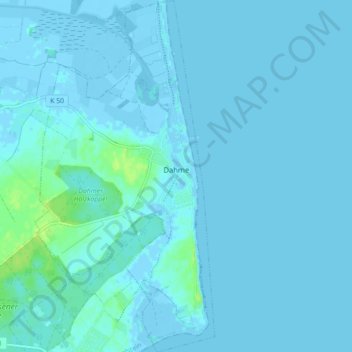
Name: Dahme topographic map, elevation, terrain.

Location: Dahme, Ostholstein, Schleswig-Holstein, 23747, Germany (54.19468 11.04981 54.24620 11.09487)

Average elevation: 3 ft

Minimum elevation: -20 ft

Maximum elevation: 39 ft

Gear up for your next adventure:

🪶LED Camping Lantern - Bright lantern for camp lighting
🧯Portable Fire Pit - Compact fire pit for camping spots
Backpacking Tent - Lightweight and durable tent for multi‑day hikes
🌡️Handheld Weather Meters - Measure wind, temp, and pressure for safe mountain travel
⛑️Personal Locator Beacon - Safety beacon for emergencies

As an Amazon Associate, this site earns from qualifying purchases at no extra cost to you.