
Thank you for supporting this site ❤️
Make a donation
Make a donation
Gear up for your next adventure:
As an Amazon Associate, this site earns from qualifying purchases at no extra cost to you.
Oberkaufungen topographic map
Click on the map to display elevation.
Thank you for supporting this site ❤️
Make a donation
Make a donation
Gear up for your next adventure:
As an Amazon Associate, this site earns from qualifying purchases at no extra cost to you.
About this map
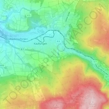
Name: Oberkaufungen topographic map, elevation, terrain.
Location: Oberkaufungen, Kaufungen, Landkreis Kassel, Hesse, Germany (51.24614 9.60744 51.30549 9.67117)
Average elevation: 1,024 ft
Minimum elevation: 574 ft
Maximum elevation: 1,775 ft
Thank you for supporting this site ❤️
Make a donation
Make a donation
Gear up for your next adventure:
As an Amazon Associate, this site earns from qualifying purchases at no extra cost to you.