
Thank you for supporting this site ❤️
Make a donation
Make a donation
Gear up for your next adventure:
As an Amazon Associate, this site earns from qualifying purchases at no extra cost to you.
Martorell topographic map
Click on the map to display elevation.
Thank you for supporting this site ❤️
Make a donation
Make a donation
Gear up for your next adventure:
As an Amazon Associate, this site earns from qualifying purchases at no extra cost to you.
About this map
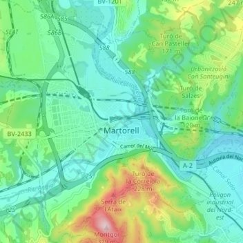
Name: Martorell topographic map, elevation, terrain.
Location: Martorell, Baix Llobregat, Barcelona, Catalonia, 08760, Spain (41.45413 1.88969 41.50341 1.95370)
Average elevation: 351 ft
Minimum elevation: 115 ft
Maximum elevation: 1,033 ft
Thank you for supporting this site ❤️
Make a donation
Make a donation
Gear up for your next adventure:
As an Amazon Associate, this site earns from qualifying purchases at no extra cost to you.