
Rogers topographic map
Click on the map to display elevation.
About this map
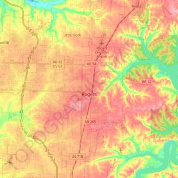
Name: Rogers topographic map, elevation, terrain.
Location: Rogers, Benton County, Arkansas, United States (36.26295 -94.22830 36.40610 -94.08062)
Average elevation: 1,289 ft
Minimum elevation: 1,070 ft
Maximum elevation: 1,440 ft
Benton County trails, hiking, mountain biking, running and outdoor activities
Other topographic maps
Click on a map to view its topography, its elevation and its terrain.
Bentonville
United States > Arkansas > Benton County > Bentonville > Bentonville
Bentonville lies in the humid subtropical climate zone (Köppen Cfa) with influence from the humid continental climate type. Bentonville experiences all four seasons and does receive cold air masses from the north, however some of the Arctic masses are blocked by the higher elevations of the Ozarks. July is…
Average elevation: 1,257 ft
Blowing Springs Bike & Fitness Park
United States > Arkansas > Benton County > Bella Vista
Average elevation: 1,152 ft