Geolocate

Pedaso topographic map

Click on the map to display elevation.

About this map

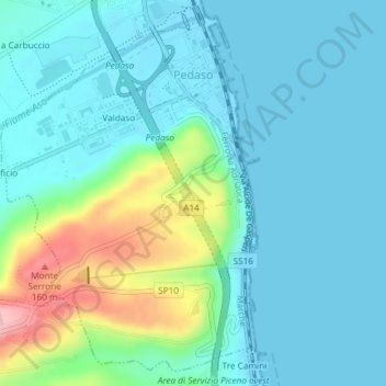
Name: Pedaso topographic map, elevation, terrain.

Location: Pedaso, Fermo, Marche, 63827, Italia (43.07841 13.82232 43.10332 13.84708)

Average elevation: 115 ft

Minimum elevation: -7 ft

Maximum elevation: 574 ft

Other topographic maps

Click on a map to view its topography, its elevation and its terrain.

Vetice

Italia > Marche > Fermo > Montefortino

Average elevation: 2,320 ft

San Martino al Faggio

Italia > Marche > Fermo > Smerillo

Average elevation: 1,585 ft

Marina Palmense

Italia > Marche > Fermo > Fermo > Torre di Palme

Average elevation: 131 ft

Montazzolino

Italia > Marche > Fermo > Montefortino

Average elevation: 2,047 ft

Gear up for your next adventure:

📦Dry Bags Set - Waterproof storage for electronics and clothes
🗃️Trail First Aid Kit - Essential kit for outdoor injuries and emergencies
📱Heavy-Duty Phone Cases - Drop-proof and waterproof protection for outdoor navigation
📚Navigation Handbooks - Master the art of reading topographic maps and using a compass
📷Action Cameras - Rugged cameras to document your journeys across rugged terrain

As an Amazon Associate, this site earns from qualifying purchases at no extra cost to you.