Geolocate

Dixton topographic map

Click on the map to display elevation.

About this map

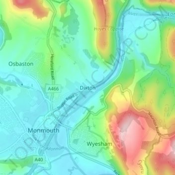
Name: Dixton topographic map, elevation, terrain.

Location: Dixton, Monmouthshire, Wales, NP25 3SJ, United Kingdom (51.79964 -2.71972 51.83964 -2.67972)

Average elevation: 259 ft

Minimum elevation: 36 ft

Maximum elevation: 843 ft

Other topographic maps

Click on a map to view its topography, its elevation and its terrain.

Wye Valley

United Kingdom > Wales > Monmouthshire

Average elevation: 548 ft

Llanbadoc

United Kingdom > Wales > Monmouthshire

Average elevation: 256 ft

Chepstow Castle

United Kingdom > Wales > Monmouthshire > Chepstow

Average elevation: 174 ft

Penallt

United Kingdom > Wales > Monmouthshire

Average elevation: 571 ft

Crucorney

United Kingdom > Wales > Monmouthshire

Average elevation: 974 ft

Blorenge

United Kingdom > Wales > Monmouthshire > Govilon

Average elevation: 1,293 ft

River Monnow

United Kingdom > Wales > Monmouthshire

Average elevation: 564 ft

River Monnow

United Kingdom > Wales > Monmouthshire

Average elevation: 564 ft

Raglan Castle

United Kingdom > Wales > Monmouthshire > Raglan

Average elevation: 194 ft

Gear up for your next adventure:

📡GPS Antenna Upgrade - Enhance GPS reception in remote terrain
🛶Inflatable Kayak - Portable kayak for rivers, lakes, and expeditions
🥇GPS Hiking Watch - Multi‑sport GPS watch with navigation and trail tracking
🧥Men's Rain Shells - Premium waterproof and breathable jackets for mountain weather
🪶Fire Starter Kit - Reliable fire starter for survival and camping

As an Amazon Associate, this site earns from qualifying purchases at no extra cost to you.