Geolocate

Blantyre topographic map

Click on the map to display elevation.

About this map

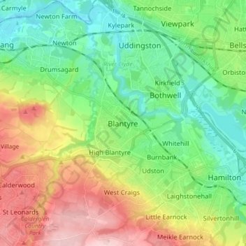
Name: Blantyre topographic map, elevation, terrain.

Location: Blantyre, South Lanarkshire, Scotland, G72 9AA, United Kingdom (55.75352 -4.13231 55.83352 -4.05231)

Average elevation: 276 ft

Minimum elevation: 30 ft

Maximum elevation: 715 ft

Gear up for your next adventure:

🔭Compact Binoculars - HD vision for scouting terrain and identifying distant landmarks
🏕️Family Camping Gear - Essentials for group camping trips
🪓Survival Multi‑Tool - Versatile tool for camp and trail tasks
🪶Camping Sleeping Pad - Comfortable sleeping pad for backpacking
🗃️Trail First Aid Kit - Essential kit for outdoor injuries and emergencies

As an Amazon Associate, this site earns from qualifying purchases at no extra cost to you.