Geolocate

Talluru topographic map

Click on the map to display elevation.

About this map

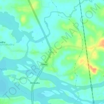
Name: Talluru topographic map, elevation, terrain.

Location: Talluru, Kundapura, Udupi District, Karnataka, 576201, India (13.63582 74.68933 13.67582 74.72933)

Average elevation: 36 ft

Minimum elevation: 3 ft

Maximum elevation: 128 ft

Other topographic maps

Click on a map to view its topography, its elevation and its terrain.

Koni

India > Karnataka > Kundapura

Average elevation: 39 ft

Koni

India > Karnataka > Kundapura > Koni

Average elevation: 39 ft

Kalawara

India > Karnataka > Kundapura > Kalavara

Average elevation: 62 ft

Gear up for your next adventure:

📦Dry Bags Set - Waterproof storage for electronics and clothes
🧼Biodegradable Camping Soap - Eco‑friendly soap for outdoor hygiene
🗺️NatGeo Topo Maps - High-quality waterproof printed topographic maps of US Parks
📦Gear Storage Bags - Organize and protect outdoor equipment
🎒Day Hiking Backpack - Lightweight backpack perfect for day trips and outdoor adventures

As an Amazon Associate, this site earns from qualifying purchases at no extra cost to you.