
Make a donation
Gear up for your next adventure:
As an Amazon Associate, this site earns from qualifying purchases at no extra cost to you.
Chesapeake City topographic map
Click on the map to display elevation.
Make a donation
Gear up for your next adventure:
As an Amazon Associate, this site earns from qualifying purchases at no extra cost to you.
About this map
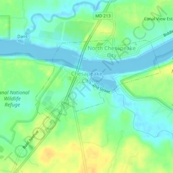
Name: Chesapeake City topographic map, elevation, terrain.
Location: Chesapeake City, Cecil County, Maryland, United States (39.51841 -75.82293 39.53286 -75.79753)
Average elevation: 36 ft
Minimum elevation: -13 ft
Maximum elevation: 85 ft
Cecil County trails, hiking, mountain biking, running and outdoor activities
Make a donation
Gear up for your next adventure:
As an Amazon Associate, this site earns from qualifying purchases at no extra cost to you.
Other topographic maps
Click on a map to view its topography, its elevation and its terrain.
Make a donation
Gear up for your next adventure:
As an Amazon Associate, this site earns from qualifying purchases at no extra cost to you.
Make a donation
Gear up for your next adventure:
As an Amazon Associate, this site earns from qualifying purchases at no extra cost to you.
Frenchtown
United States > Maryland > Cecil County > Perryville > Frenchtown
Average elevation: 115 ft