
Make a donation
Gear up for your next adventure:
As an Amazon Associate, this site earns from qualifying purchases at no extra cost to you.
Romanoro topographic map
Click on the map to display elevation.
Make a donation
Gear up for your next adventure:
As an Amazon Associate, this site earns from qualifying purchases at no extra cost to you.
About this map
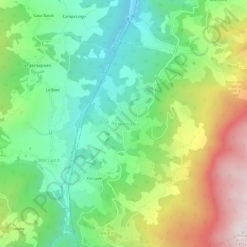
Name: Romanoro topographic map, elevation, terrain.
Average elevation: 2,684 ft
Minimum elevation: 1,673 ft
Maximum elevation: 4,432 ft
Make a donation
Gear up for your next adventure:
As an Amazon Associate, this site earns from qualifying purchases at no extra cost to you.
Other topographic maps
Click on a map to view its topography, its elevation and its terrain.
Modena
Italië > Emilia-Romagna > Modena
Deze kathedraal bevindt zich in het historisch centrum van Modena. De duomo is een heel belangrijk voorbeeld van de Lombardische romaanse architectuur. De bouw nam een aanvang in 1099 en werd in 1184 beëindigd. De gotische campanile (1224-1319), de Torre della Ghirlandina, is het symbool van de stad.…
Average elevation: 131 ft
Make a donation
Gear up for your next adventure:
As an Amazon Associate, this site earns from qualifying purchases at no extra cost to you.