Geolocate

Paola topographic map

Click on the map to display elevation.

About this map

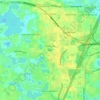
Name: Paola topographic map, elevation, terrain.

Location: Paola, Seminole County, Florida, 32746, United States (28.77388 -81.38285 28.81388 -81.34285)

Average elevation: 66 ft

Minimum elevation: 26 ft

Maximum elevation: 102 ft

Seminole County trails, hiking, mountain biking, running and outdoor activities

Other topographic maps

Click on a map to view its topography, its elevation and its terrain.

Paulucci Park

United States > Florida > Seminole County > Sanford

Average elevation: 16 ft

Fern Park

United States > Florida > Seminole County > Fern Park

Average elevation: 98 ft

Lake Harney

United States > Florida > Seminole County

Average elevation: 10 ft

Cranes Roost

United States > Florida > Seminole County

Average elevation: 85 ft

Gear up for your next adventure:

🔌USB Car Charger - Car charger for on‑the‑go power needs
🏫Relief Map Kits - Hands-on tools for teaching landforms and elevation
🧦Hiking Socks - Comfortable socks to prevent blisters on long hikes
🧭Compass with Lanyard - Easy‑carry compass for navigation
🎒Gear Packing Cubes - Organize your backpack efficiently

As an Amazon Associate, this site earns from qualifying purchases at no extra cost to you.