
Make a donation
Gear up for your next adventure:
As an Amazon Associate, this site earns from qualifying purchases at no extra cost to you.
Corsica topographic map
Click on the map to display elevation.
Make a donation
Gear up for your next adventure:
As an Amazon Associate, this site earns from qualifying purchases at no extra cost to you.
Corsica
Under the Köppen climate classification scheme, coastal regions are characterized by a hot-summer Mediterranean climate (Csa). Further inland, a warm-summer Mediterranean climate (Csb) is more common. At the highest elevation locations, small areas with a subarctic climate (Dsc, Dfc) and the rare cold-summer Mediterranean climate (Csc) can be found.
Make a donation
Gear up for your next adventure:
As an Amazon Associate, this site earns from qualifying purchases at no extra cost to you.
About this map
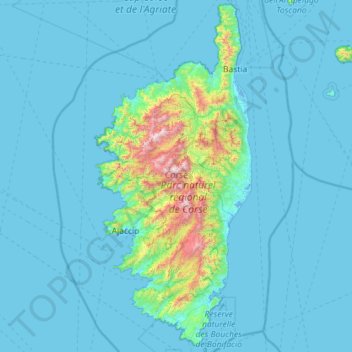
Name: Corsica topographic map, elevation, terrain.
Location: Corsica, Metropolitan France, France (41.33319 8.53472 43.02771 9.56001)
Average elevation: 456 ft
Minimum elevation: -16 ft
Maximum elevation: 8,353 ft
Make a donation
Gear up for your next adventure:
As an Amazon Associate, this site earns from qualifying purchases at no extra cost to you.
Other topographic maps
Click on a map to view its topography, its elevation and its terrain.
Pont de Chazeaux
France > Auvergne-Rhône-Alpes > Haute-Loire > Monistrol-sur-Loire
Average elevation: 2,398 ft
Make a donation
Gear up for your next adventure:
As an Amazon Associate, this site earns from qualifying purchases at no extra cost to you.
Paris
Paris in its early history had only the rivers Seine and Bièvre for water. From 1809, the Canal de l'Ourcq provided Paris with water from less-polluted rivers to the north-east of the capital. From 1857, the civil engineer Eugène Belgrand, under Napoleon III, oversaw the construction of a series of new…
Average elevation: 246 ft
Le Barnagaud
France > Nouvelle-Aquitaine > Haute-Vienne > La Croisille-sur-Briance
Average elevation: 1,804 ft
Make a donation
Gear up for your next adventure:
As an Amazon Associate, this site earns from qualifying purchases at no extra cost to you.
Aix-en-Provence
France > Provence-Alpes-Côte d'Azur > Bouches-du-Rhône > Aix-en-Provence
Average elevation: 915 ft
Les Champs
France > Auvergne-Rhône-Alpes > Upper Savoy > Saint-Jean-d'Aulps
Average elevation: 3,917 ft
Make a donation
Gear up for your next adventure:
As an Amazon Associate, this site earns from qualifying purchases at no extra cost to you.
Pic Gaspard
France > Provence-Alpes-Côte d'Azur > Hautes-Alpes > Villar-d'Arêne
Average elevation: 10,318 ft
Saint-Michel
France > Provence-Alpes-Côte d'Azur > Alpes-de-Haute-Provence > Moustiers-Sainte-Marie
Average elevation: 2,398 ft
Make a donation
Gear up for your next adventure:
As an Amazon Associate, this site earns from qualifying purchases at no extra cost to you.
Make a donation
Gear up for your next adventure:
As an Amazon Associate, this site earns from qualifying purchases at no extra cost to you.
Mont Blanc / Monte Bianco
France > Auvergne-Rhône-Alpes > Upper Savoy > Saint-Gervais-les-Bains
The climate is cold and temperate (Köppen climate classification Cfb), and is greatly influenced by altitude. Being the highest part of the Alps, Mont Blanc and surrounding mountains can create their own weather patterns. Temperatures drop as the mountains gain in height, and the summit of Mont Blanc is a…
Average elevation: 13,425 ft
Make a donation
Gear up for your next adventure:
As an Amazon Associate, this site earns from qualifying purchases at no extra cost to you.
Mer de Glace
France > Auvergne-Rhône-Alpes > Upper Savoy > Chamonix-Mont-Blanc
The glacier lies above the Chamonix valley. The pressure within the ice is known to reach at least 30 atmospheres. The Mer de Glace can be considered as originating at an elevation of 2,100 metres (6,900 ft), just north of the Aiguille du Tacul, where it is formed by the confluence of the Glacier de Leschaux…
Average elevation: 7,621 ft
Argentière
France > Auvergne-Rhône-Alpes > Upper Savoy > Chamonix-Mont-Blanc
Argentière (French pronunciation: [aʁʒɑ̃tjɛʁ]) is a picturesque skiing, alpine walking and mountaineering village in the French Alps, part of the commune of Chamonix-Mont-Blanc, at an altitude of 1,252 m (4,108 ft).
Average elevation: 5,492 ft
Make a donation
Gear up for your next adventure:
As an Amazon Associate, this site earns from qualifying purchases at no extra cost to you.
Chateauneuf de Mazenc
France > Auvergne-Rhône-Alpes > Drôme > La Bégude-de-Mazenc
Average elevation: 781 ft
Make a donation
Gear up for your next adventure:
As an Amazon Associate, this site earns from qualifying purchases at no extra cost to you.
Make a donation
Gear up for your next adventure:
As an Amazon Associate, this site earns from qualifying purchases at no extra cost to you.
Bayonne
France > New Aquitaine > Pyrénées-Atlantiques > Bayonne > Bayonne
In the late Quaternary, the current topographic physiognomy was formed—i.e. a set of hills overlooking a swampy lowland. The promontory of Bassussarry–Marracq ultimately extended to the Labourdin foothills. The Grand Bayonne hill is an example. Similarly, on the right bank of the Nive, the heights of…
Average elevation: 75 ft
Mer de Glace
France > Auvergne-Rhône-Alpes > Upper Savoy > Chamonix-Mont-Blanc
The glacier lies above the Chamonix valley. The pressure within the ice is known to reach at least 30 atmospheres. The Mer de Glace can be considered as originating at an elevation of 2,100 metres (6,900 ft), just north of the Aiguille du Tacul [fr], where it is formed by the confluence of the Glacier de…
Average elevation: 7,618 ft
Make a donation
Gear up for your next adventure:
As an Amazon Associate, this site earns from qualifying purchases at no extra cost to you.
Make a donation
Gear up for your next adventure:
As an Amazon Associate, this site earns from qualifying purchases at no extra cost to you.
Le Château du Bois
France > Bourgogne – Franche-Comté > Nièvre > Entrains-sur-Nohain
Average elevation: 804 ft
Plan Sarrain
France > Provence-Alpes-Côte d'Azur > Maritime Alps > Mouans-Sartoux
Average elevation: 318 ft
Make a donation
Gear up for your next adventure:
As an Amazon Associate, this site earns from qualifying purchases at no extra cost to you.
Make a donation
Gear up for your next adventure:
As an Amazon Associate, this site earns from qualifying purchases at no extra cost to you.
Sur Ilots du Bas
France > Bourgogne – Franche-Comté > Haute-Saône > Renaucourt
Average elevation: 761 ft
Make a donation
Gear up for your next adventure:
As an Amazon Associate, this site earns from qualifying purchases at no extra cost to you.
Pointe du Hoc
France > Normandy > Calvados > Cricqueville-en-Bessin > Le Guay
Average elevation: 36 ft
Make a donation
Gear up for your next adventure:
As an Amazon Associate, this site earns from qualifying purchases at no extra cost to you.
Make a donation
Gear up for your next adventure:
As an Amazon Associate, this site earns from qualifying purchases at no extra cost to you.
La Toussuire
France > Auvergne-Rhône-Alpes > Savoy > Fontcouverte-la-Toussuire
Average elevation: 5,610 ft
Make a donation
Gear up for your next adventure:
As an Amazon Associate, this site earns from qualifying purchases at no extra cost to you.
Make a donation
Gear up for your next adventure:
As an Amazon Associate, this site earns from qualifying purchases at no extra cost to you.
Pic Gaspard
France > Provence-Alpes-Côte d'Azur > Hautes-Alpes > Villar-d'Arêne
Average elevation: 10,318 ft
Make a donation
Gear up for your next adventure:
As an Amazon Associate, this site earns from qualifying purchases at no extra cost to you.
Island
France > Auvergne-Rhône-Alpes > Métropole de Lyon > Collonges-au-Mont-d'Or
Average elevation: 715 ft
Paris Basin
France > Ile-de-France > Essonne > Bièvres
The landscape is one of very broad valleys (flood plains), modest watershed hills and well-drained plateaux of comparatively little altitude. In the south-east and east the plain of Champagne and the Seuil de Bourgogne (Threshold of Burgundy) differential erosion of the strata has left low scarps with the dip…
Average elevation: 413 ft
Make a donation
Gear up for your next adventure:
As an Amazon Associate, this site earns from qualifying purchases at no extra cost to you.
Barrage de Roselend
France > Auvergne-Rhône-Alpes > Savoy > Beaufort
The dam has a maximum height of 150 m (492 ft) and a length of 804 m (2,638 ft). It is 3 m (10 ft) wide at its crest and 22 m (72 ft) wide at its base. The dam has a structural volume of 945,000 m3 (1,236,013 cu yd). Its reservoir, Lac de Roselend, can store 187,000,000 m3 (151,603 acre⋅ft) of water and has…
Average elevation: 5,243 ft
Les Frasserands
France > Auvergne-Rhône-Alpes > Upper Savoy > Chamonix-Mont-Blanc > Argentière
Average elevation: 5,591 ft
Make a donation
Gear up for your next adventure:
As an Amazon Associate, this site earns from qualifying purchases at no extra cost to you.
Mont Orohena
France > French Polynesia > Windward Islands > Māhina
Mont Orohena is a mountain located in the South Pacific, on the island of Tahiti. With an elevation of 2,241 metres (7,352 ft) above sea level, it is the highest point of French Polynesia. Mont Orohena is an extinct volcano and ranks 7th in the world for topographic isolation.
Average elevation: 4,206 ft
Hôtellerie du Cirque
France > Occitania > Hautes Pyrenees > Gavarnie-Gèdre > Gavarnie
Average elevation: 6,526 ft
Make a donation
Gear up for your next adventure:
As an Amazon Associate, this site earns from qualifying purchases at no extra cost to you.
Mont Ventoux
France > Provence-Alpes-Côte d'Azur > Vaucluse > Saint-Léger-du-Ventoux
There are two small ski stations on the mountain: "Mont Serein" on the north side, and "Chalet Reynard" on the south. High winds and the modest elevation tend to limit the ski season. Weather conditions are such that the northern slope is often icy, leading to a saying among people of the surrounding region…
Average elevation: 5,108 ft
L'Isle-sur-la-Sorgue
France > Provence-Alpes-Côte d'Azur > Vaucluse > L'Isle-sur-la-Sorgue > L'Isle-sur-la-Sorgue
Average elevation: 262 ft
Les Granges
France > Auvergne-Rhône-Alpes > Savoy > Saint-Martin-de-Belleville
Average elevation: 5,915 ft
Contournat
France > Auvergne-Rhône-Alpes > Puy-de-Dôme > Saint-Julien-de-Coppel
Average elevation: 1,555 ft
Make a donation
Gear up for your next adventure:
As an Amazon Associate, this site earns from qualifying purchases at no extra cost to you.
Saint-Jean-de-Maurienne
France > Auvergne-Rhône-Alpes > Savoy > Saint-Jean-de-Maurienne > Saint-Jean-de-Maurienne
Average elevation: 3,573 ft
Make a donation
Gear up for your next adventure:
As an Amazon Associate, this site earns from qualifying purchases at no extra cost to you.
Chartres Cathedral
France > Centre-Val de Loire > Eure-et-Loir > Chartres
The elevation of the nave, showing the gallery on the ground level; the narrow triforium; and, on top, the windows of the clerestory
Average elevation: 486 ft
Mont Blanc / Monte Bianco
France > Auvergne-Rhône-Alpes > Upper Savoy > Saint-Gervais-les-Bains
The climate is cold and temperate (Köppen climate classification Cfb), and is greatly influenced by altitude. Being the highest part of the Alps, Mont Blanc and surrounding mountains can create their own weather patterns. Temperatures drop as the mountains gain in height, and the summit of Mont Blanc is a…
Average elevation: 13,425 ft
Make a donation
Gear up for your next adventure:
As an Amazon Associate, this site earns from qualifying purchases at no extra cost to you.