
Finlayson topographic map
Click on the map to display elevation.
About this map
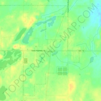
Name: Finlayson topographic map, elevation, terrain.
Location: Finlayson, Pine County, Minnesota, United States (46.18735 -92.94971 46.21639 -92.90273)
Average elevation: 1,112 ft
Minimum elevation: 1,066 ft
Maximum elevation: 1,148 ft
Pine County trails, hiking, mountain biking, running and outdoor activities
Other topographic maps
Click on a map to view its topography, its elevation and its terrain.
Big Pine Lake
United States > Minnesota > Pine County > Pine Lake Township
Average elevation: 1,112 ft