
Hiiraan topographic map
Interactive map
Click on the map to display elevation.
About this map
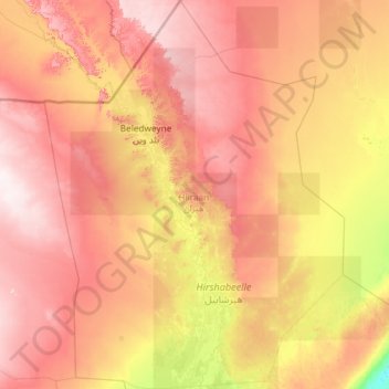
Name: Hiiraan topographic map, elevation, terrain.
Location: Hiiraan, Somalia (3.20000 44.58957 5.53638 46.40000)
Average elevation: 883 ft
Minimum elevation: 56 ft
Maximum elevation: 1,913 ft
Other topographic maps
Click on a map to view its topography, its elevation and its terrain.
Beledweyne District
Beledweyne District, Hiiraan, Hirshabelle, Somalia
Average elevation: 1,004 ft
Hiran
Somalia > Hiiraan > Beledweyne District
Hiran, Beledweyne District, Hiiraan, Hirshabelle, Somalia
Average elevation: 853 ft
Beledweyne
Somalia > Hiiraan > Beledweyne
Beledweyne, Belet Weyne بلد وين, Hiiraan, Somalia
Average elevation: 725 ft