
Thank you for supporting this site ❤️
Make a donation
Make a donation
Gear up for your next adventure:
As an Amazon Associate, this site earns from qualifying purchases at no extra cost to you.
Hiran topographic map
Click on the map to display elevation.
Thank you for supporting this site ❤️
Make a donation
Make a donation
Gear up for your next adventure:
As an Amazon Associate, this site earns from qualifying purchases at no extra cost to you.
About this map
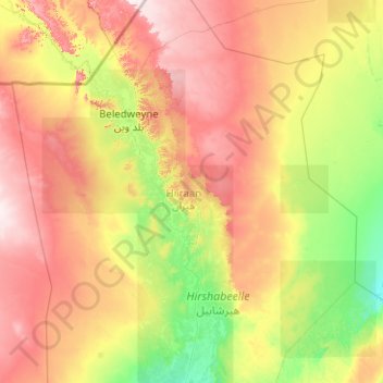
Name: Hiran topographic map, elevation, terrain.
Location: Hiran, Beledweyne District, Hiiraan, Hirshabelle, Somalia (3.36170 44.53331 5.36170 46.53331)
Average elevation: 853 ft
Minimum elevation: 390 ft
Maximum elevation: 1,759 ft
Thank you for supporting this site ❤️
Make a donation
Make a donation
Gear up for your next adventure:
As an Amazon Associate, this site earns from qualifying purchases at no extra cost to you.