
Make a donation
Gear up for your next adventure:
As an Amazon Associate, this site earns from qualifying purchases at no extra cost to you.
Palitana topographic map
Click on the map to display elevation.
Make a donation
Gear up for your next adventure:
As an Amazon Associate, this site earns from qualifying purchases at no extra cost to you.
Palitana
Palitana is located at 21°31′N 71°50′E / 21.52°N 71.83°E / 21.52; 71.83. It has an average elevation of 67 metres (219 feet). The Palitana dam, an irrigation resource, is on the Shetrunji River.
Make a donation
Gear up for your next adventure:
As an Amazon Associate, this site earns from qualifying purchases at no extra cost to you.
About this map
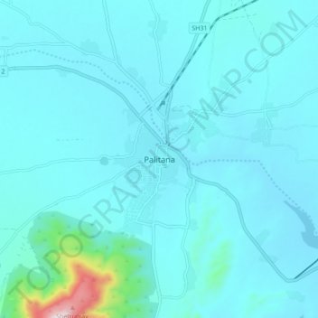
Name: Palitana topographic map, elevation, terrain.
Location: Palitana, Palitana Taluka, Bhavnagar, Gujarat, 364270, India (21.48361 71.78196 21.56361 71.86196)
Average elevation: 302 ft
Minimum elevation: 151 ft
Maximum elevation: 1,929 ft
Make a donation
Gear up for your next adventure:
As an Amazon Associate, this site earns from qualifying purchases at no extra cost to you.
Other topographic maps
Click on a map to view its topography, its elevation and its terrain.