
Make a donation
Gear up for your next adventure:
As an Amazon Associate, this site earns from qualifying purchases at no extra cost to you.
Har Tavor topographic map
Click on the map to display elevation.
Make a donation
Gear up for your next adventure:
As an Amazon Associate, this site earns from qualifying purchases at no extra cost to you.
About this map
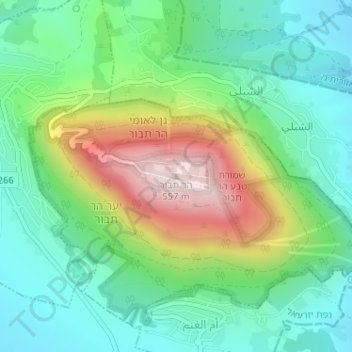
Name: Har Tavor topographic map, elevation, terrain.
Location: Har Tavor, Jezreel Subdistrict, North District, Israel (32.68706 35.38957 32.68716 35.38967)
Average elevation: 820 ft
Minimum elevation: 331 ft
Maximum elevation: 1,841 ft
Make a donation
Gear up for your next adventure:
As an Amazon Associate, this site earns from qualifying purchases at no extra cost to you.
Other topographic maps
Click on a map to view its topography, its elevation and its terrain.
Sea of Galilee
After 5 years of drought as of 2018, Sea of Galilee is expected to get to the black line. The black elevation line is the lowest depth from which irreversible damage begin and no water can be pumped out anymore. Israel Oceanographic and Limnological Research describe it as "The black line marks −214.87 m,…
Average elevation: -220 ft
Make a donation
Gear up for your next adventure:
As an Amazon Associate, this site earns from qualifying purchases at no extra cost to you.
Tiberias
Tiberias is located on the shore of the Sea of Galilee and the western slopes of the Jordan Rift Valley overlooking the lake, in the elevation range of −200 to 200 metres (−660–660 feet). Tiberias has a hot semi-arid climate (Köppen: BSh) that borders a hot-summer Mediterranean climate (Köppen: Csa),…
Average elevation: -157 ft
Make a donation
Gear up for your next adventure:
As an Amazon Associate, this site earns from qualifying purchases at no extra cost to you.
Make a donation
Gear up for your next adventure:
As an Amazon Associate, this site earns from qualifying purchases at no extra cost to you.
Korazim National Park
Israel > North District > Mevoot HaHermon Regional Council
Average elevation: 318 ft
Zippori (Resh-Laqish) National Park
Israel > North District > Jezreel Valley Regional Council > Zippori
Average elevation: 614 ft
Make a donation
Gear up for your next adventure:
As an Amazon Associate, this site earns from qualifying purchases at no extra cost to you.
Nimrod Fortress National Park
Israel > North District > Golan Regional Council
Average elevation: 2,211 ft
Nazareth
As of the early 1990s, no city plans drafted by Nazareth Municipality have been approved by the government (both the British Mandate and later Israel) since 1942. This has left many people in Nazareth who vote in the city's municipal elections and receive services from its municipality effectively outside of…
Average elevation: 1,073 ft
Make a donation
Gear up for your next adventure:
As an Amazon Associate, this site earns from qualifying purchases at no extra cost to you.
Safed
Safed (/ˈsɑːfɛd/ SAH-fed; Arabic: صَفَد, romanized: Ṣafad), also known as Tzfat and officially as Zefat (Hebrew: צְפַת, romanized: Ṣəp̄aṯ), is a city in the Northern District of Israel. Located at an elevation of up to 937 m (3,074 ft), Safed is the highest city in the Galilee and in…
Average elevation: 1,801 ft
Make a donation
Gear up for your next adventure:
As an Amazon Associate, this site earns from qualifying purchases at no extra cost to you.
Make a donation
Gear up for your next adventure:
As an Amazon Associate, this site earns from qualifying purchases at no extra cost to you.
Make a donation
Gear up for your next adventure:
As an Amazon Associate, this site earns from qualifying purchases at no extra cost to you.
Nazareth
As of the early 1990s, no city plans drafted by Nazareth Municipality have been approved by the government (both the British Mandate and later Israel) since 1942. This has left many people in Nazareth who vote in the city's municipal elections and receive services from its municipality effectively outside of…
Average elevation: 1,056 ft
El Rom
Israel > North District > Golan Regional Council
The kibbutz is about ten kilometers (6.2 mi) south of Mount Hermon, at an elevation of 1,050–1,070 meters (3,440–3,510 ft) above sea level. El Rom and the nearby moshav Odem are the two Jewish settlements in Israel with the highest elevation after Nimrod.
Average elevation: 3,484 ft
Make a donation
Gear up for your next adventure:
As an Amazon Associate, this site earns from qualifying purchases at no extra cost to you.
Kiryat Shmona
Kiryat Shmona is located in the Galilee panhandle next to Hula Valley, about 5 kilometres (3 miles) south and 2 km (1 mile) east of the Israel–Lebanon border. Its elevation is about 150 metres (492 feet) above sea level.
Average elevation: 928 ft
Karmiel
Karmiel is located on the Acre–Safed road, on the northern edge of the Lower Galilee. It lies in the Beit HaKerem Valley and its elevation is 330 m (1,082.68 ft). The Hilazon Stream passes slightly to the south of Karmiel. Its tributaries, the Shezor and Shagor Streams pass through Karmiel on the east and…
Average elevation: 1,043 ft
Make a donation
Gear up for your next adventure:
As an Amazon Associate, this site earns from qualifying purchases at no extra cost to you.
Safed
Safed (/ˈsɑːfɛd/ SAH-fed; Arabic: صَفَد, romanized: Ṣafad), also known as Tzfat and officially as Zefat (Hebrew: צְפַת, romanized: Ṣəp̄aṯ), is a city in the Northern District of Israel. Located at an elevation of up to 937 m (3,074 ft), Safed is the highest city in the Galilee and in…
Average elevation: 1,801 ft
Make a donation
Gear up for your next adventure:
As an Amazon Associate, this site earns from qualifying purchases at no extra cost to you.
Make a donation
Gear up for your next adventure:
As an Amazon Associate, this site earns from qualifying purchases at no extra cost to you.
Make a donation
Gear up for your next adventure:
As an Amazon Associate, this site earns from qualifying purchases at no extra cost to you.
Make a donation
Gear up for your next adventure:
As an Amazon Associate, this site earns from qualifying purchases at no extra cost to you.
Karmiel
Karmiel is located on the Acre–Safed road, on the northern edge of the Lower Galilee. It lies in the Beit HaKerem Valley and its elevation is 330 m (1,082.68 ft). The Hilazon Stream passes slightly to the south of Karmiel. Its tributaries, the Shezor and Shagor Streams pass through Karmiel on the east and…
Average elevation: 1,043 ft
Make a donation
Gear up for your next adventure:
As an Amazon Associate, this site earns from qualifying purchases at no extra cost to you.
Majdal Shams
The name "Majdal Shams" originates from Aramaic, meaning: "tower of sun" in reference (possibly) to the town's elevation. Another hypothesis suggests that the town was originally called Majdal al-Sham (Majdal of Damascus) to distinguish it from the towns of similar names, like Majdal Zun and Majdal Salem in…
Average elevation: 4,072 ft
Beit Shean
During this period, the inhabitants of Baysan were mainly Muslim, but there were some Jews. The 14th century topographer Ishtori Haparchi settled there and completed his work "Bulb and Flower" (Hebrew: כפתור ופרח, romanized: Kaftor vaFeraḥ) in 1322, the first Hebrew book on the geography of the Land of Israel.
Average elevation: -453 ft
Make a donation
Gear up for your next adventure:
As an Amazon Associate, this site earns from qualifying purchases at no extra cost to you.
Make a donation
Gear up for your next adventure:
As an Amazon Associate, this site earns from qualifying purchases at no extra cost to you.
Yehudia - Brechat HaMeshushim Site Nature Reserve
Israel > North District > Golan Regional Council
Average elevation: 299 ft
Ein Avazim Nature Reserve
Israel > North District > Mevoot HaHermon Regional Council
Average elevation: 610 ft
Make a donation
Gear up for your next adventure:
As an Amazon Associate, this site earns from qualifying purchases at no extra cost to you.
Make a donation
Gear up for your next adventure:
As an Amazon Associate, this site earns from qualifying purchases at no extra cost to you.
Safed
Safed (Arabic: صفد, romanized: Ṣafad), also known as Tzfat (Hebrew: צְפַת, romanized: Ṣəfaṯ), is a city in the Northern District of Israel. Located at an elevation of up to 937 m (3,074 ft), Safed is the highest city in the Galilee and in Israel.
Average elevation: 1,801 ft
Make a donation
Gear up for your next adventure:
As an Amazon Associate, this site earns from qualifying purchases at no extra cost to you.
Karmiel
Karmiel is located on the Acre–Safed road, on the northern edge of the Lower Galilee. It lies in the Beit HaKerem Valley and its elevation is 330 m (1,082.68 ft). The Hilazon Stream passes slightly to the south of Karmiel. Its tributaries, the Shezor and Shagor Streams pass through Karmiel on the east and…
Average elevation: 1,033 ft
Make a donation
Gear up for your next adventure:
As an Amazon Associate, this site earns from qualifying purchases at no extra cost to you.
Nazareth
As of the early 1990s, no city plans drafted by Nazareth Municipality have been approved by the government (both the British Mandate and later Israel) since 1942. This has left many people in Nazareth who vote in the city's municipal elections and receive services from its municipality effectively outside of…
Average elevation: 1,056 ft
Kiryat Shmona
Kiryat Shmona is located in the Finger of the Galilee next to Hula Valley, about 5 kilometres (3 miles) south and 2 km (1 mile) east of the Israel–Lebanon border. Its elevation is about 150 metres (492 feet) above sea level.
Average elevation: 928 ft
Matat
Israel > North District > Maale Yosef Regional Council
Mattat's name is equivalent in gematria to 840, its altitude in metres. The high location and mountainous region provides the town with a relatively temperate climate. Summer temperatures rarely break 30 °C and humidity is low, and summer nights are even chilly. The winters are cold and wet, with an average…
Average elevation: 2,477 ft
Make a donation
Gear up for your next adventure:
As an Amazon Associate, this site earns from qualifying purchases at no extra cost to you.
Golan Heights
The plateau that Israel controls is part of a larger area of volcanic basalt fields stretching north and east that were created in the series of volcanic eruptions that began recently in geological terms, almost 4 million years ago. The rock forming the mountainous area in the northern Golan Heights,…
Average elevation: 1,719 ft
Make a donation
Gear up for your next adventure:
As an Amazon Associate, this site earns from qualifying purchases at no extra cost to you.
Safed
Safed (Arabic: صفد, romanized: Ṣafad), also known as Tzfat (Hebrew: צְפַת, romanized: Ṣəfaṯ), is a city in the Northern District of Israel. Located at an elevation of up to 937 m (3,074 ft), Safed is the highest city in the Galilee and in Israel.
Average elevation: 1,801 ft
Make a donation
Gear up for your next adventure:
As an Amazon Associate, this site earns from qualifying purchases at no extra cost to you.
Make a donation
Gear up for your next adventure:
As an Amazon Associate, this site earns from qualifying purchases at no extra cost to you.