
Thank you for supporting this site ❤️
Make a donation
Make a donation
Gear up for your next adventure:
As an Amazon Associate, this site earns from qualifying purchases at no extra cost to you.
Rusape topographic map
Click on the map to display elevation.
Thank you for supporting this site ❤️
Make a donation
Make a donation
Gear up for your next adventure:
As an Amazon Associate, this site earns from qualifying purchases at no extra cost to you.
About this map
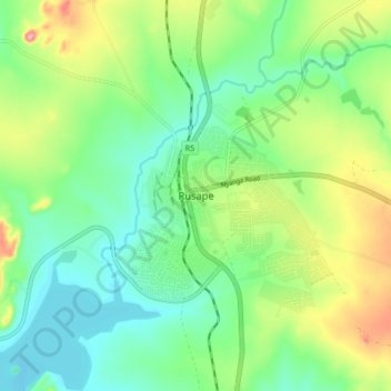
Name: Rusape topographic map, elevation, terrain.
Location: Rusape, Makoni, Manicaland Province, Zimbabwe (-18.57348 32.08568 -18.49348 32.16568)
Average elevation: 4,642 ft
Minimum elevation: 4,485 ft
Maximum elevation: 4,964 ft
Thank you for supporting this site ❤️
Make a donation
Make a donation
Gear up for your next adventure:
As an Amazon Associate, this site earns from qualifying purchases at no extra cost to you.