
Oued Zehour topographic map
Interactive map
Click on the map to display elevation.
About this map
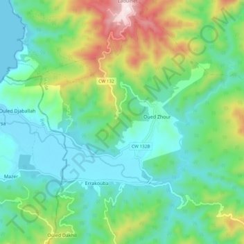
Name: Oued Zehour topographic map, elevation, terrain.
Location: Oued Zehour, El Milia, Daïra El Milia, Jijel, Algérie (36.90590 6.25090 36.94431 6.34586)
Average elevation: 640 ft
Minimum elevation: 0 ft
Maximum elevation: 2,356 ft
Other topographic maps
Click on a map to view its topography, its elevation and its terrain.
Barrage Boussiaba
Algérie > Jijel > Daïra El Milia > El Milia > Ouled Arbi
Barrage Boussiaba, Ouled Arbi, El Milia, Daïra El Milia, Jijel, Algérie
Average elevation: 472 ft
Ouled Ali
Algérie > Jijel > Daïra El Milia > El Milia
Ouled Ali, El Milia, Daïra El Milia, Jijel, 18300, Algérie
Average elevation: 423 ft