
Make a donation
Gear up for your next adventure:
As an Amazon Associate, this site earns from qualifying purchases at no extra cost to you.
Larrau topographic map
Click on the map to display elevation.
Make a donation
Gear up for your next adventure:
As an Amazon Associate, this site earns from qualifying purchases at no extra cost to you.
About this map
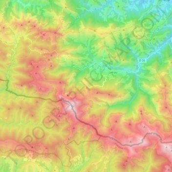
Name: Larrau topographic map, elevation, terrain.
Average elevation: 3,363 ft
Minimum elevation: 804 ft
Maximum elevation: 6,598 ft
Make a donation
Gear up for your next adventure:
As an Amazon Associate, this site earns from qualifying purchases at no extra cost to you.
Other topographic maps
Click on a map to view its topography, its elevation and its terrain.
Pico Lakora
Francia > Nueva Aquitania > Pyrénées-Atlantiques > Sainte-Engrâce
Average elevation: 4,928 ft
Make a donation
Gear up for your next adventure:
As an Amazon Associate, this site earns from qualifying purchases at no extra cost to you.
Col de Marie-Blanque
Francia > Nueva Aquitania > Pyrénées-Atlantiques > Bilhères
Average elevation: 3,711 ft
Pic d'Orisson / Harburu
Francia > Nueva Aquitania > Pyrénées-Atlantiques > Saint-Michel
Average elevation: 2,680 ft
Make a donation
Gear up for your next adventure:
As an Amazon Associate, this site earns from qualifying purchases at no extra cost to you.
Make a donation
Gear up for your next adventure:
As an Amazon Associate, this site earns from qualifying purchases at no extra cost to you.
Gran Playa
Francia > Nueva Aquitania > Pyrénées-Atlantiques > San Juan de Luz
Average elevation: 46 ft
Ibarrun
Francia > Nueva Aquitania > Pyrénées-Atlantiques > Saint-Pée-sur-Nivelle
Average elevation: 223 ft
Lac du Montagnon
Francia > Nueva Aquitania > Pyrénées-Atlantiques > Accous
Average elevation: 5,810 ft
Make a donation
Gear up for your next adventure:
As an Amazon Associate, this site earns from qualifying purchases at no extra cost to you.
Puntal de Oloron
Francia > Nueva Aquitania > Pyrénées-Atlantiques > Sainte-Engrâce
Average elevation: 4,941 ft
Undurein
Francia > Nueva Aquitania > Pyrénées-Atlantiques > Espès-Undurein > Undurein
Average elevation: 512 ft
Make a donation
Gear up for your next adventure:
As an Amazon Associate, this site earns from qualifying purchases at no extra cost to you.