Geolocate

Auric topographic map

Click on the map to display elevation.

About this map

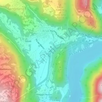
Name: Auric topographic map, elevation, terrain.

Location: Auric, Sassei, Mellame, Arsiè, Belluno, Veneto, Italy (45.97784 11.75878 45.97848 11.75980)

Average elevation: 1,322 ft

Minimum elevation: 817 ft

Maximum elevation: 2,408 ft

Gear up for your next adventure:

📌Outdoor GPS Map App - Apps and devices for digital topographic navigation
🗺️Topographic Maps - Detailed topo maps for hiking, exploring and outdoor navigation
👟Trail Running Shoes - Lightweight shoes for trail runners
🧭GPS Watch Accessories - Bands and chargers for GPS watches
📷Action Camera - Capture your outdoor adventures in HD

As an Amazon Associate, this site earns from qualifying purchases at no extra cost to you.