
Make a donation
Gear up for your next adventure:
As an Amazon Associate, this site earns from qualifying purchases at no extra cost to you.
Bauzenbach topographic map
Click on the map to display elevation.
Make a donation
Gear up for your next adventure:
As an Amazon Associate, this site earns from qualifying purchases at no extra cost to you.
About this map
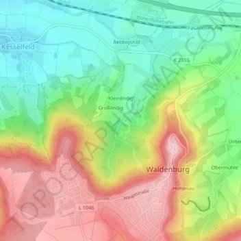
Name: Bauzenbach topographic map, elevation, terrain.
Average elevation: 1,319 ft
Minimum elevation: 1,027 ft
Maximum elevation: 1,670 ft
Make a donation
Gear up for your next adventure:
As an Amazon Associate, this site earns from qualifying purchases at no extra cost to you.
Other topographic maps
Click on a map to view its topography, its elevation and its terrain.
Obersteinbach
Deutschland > Baden-Württemberg > Hohenlohekreis > Waldenburg
Average elevation: 1,460 ft
Domäne Hohebuch
Deutschland > Baden-Württemberg > Hohenlohekreis > Waldenburg
Average elevation: 1,171 ft
Gewerbepark Hohenlohe
Deutschland > Baden-Württemberg > Hohenlohekreis > Waldenburg
Average elevation: 1,178 ft
Make a donation
Gear up for your next adventure:
As an Amazon Associate, this site earns from qualifying purchases at no extra cost to you.