Geolocate

Maasin topographic map

Click on the map to display elevation.

About this map

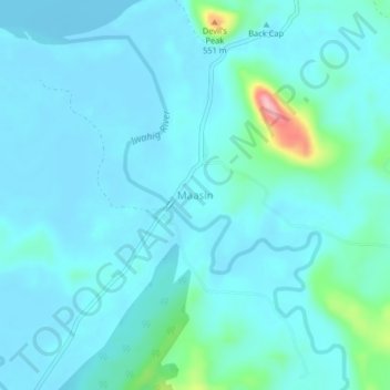
Name: Maasin topographic map, elevation, terrain.

Location: Maasin, Palawan, Mimaropa, 5304, Philippines (9.26241 118.05596 9.30241 118.09596)

Average elevation: 69 ft

Minimum elevation: -16 ft

Maximum elevation: 548 ft

Gear up for your next adventure:

🔪Outdoor Multitools - Essential survival tools for gear repair and field use
🧷Carabiner Set - Durable clips for gear attachment
🌐World Map Poster - Decorative world maps with topographic info
🔋Solar Power Banks - Keep your GPS and phone charged in remote wilderness areas
🌡️Portable Weather Meter - Track weather conditions on the trail

As an Amazon Associate, this site earns from qualifying purchases at no extra cost to you.