
Make a donation
Gear up for your next adventure:
As an Amazon Associate, this site earns from qualifying purchases at no extra cost to you.
Poeke topographic map
Click on the map to display elevation.
Make a donation
Gear up for your next adventure:
As an Amazon Associate, this site earns from qualifying purchases at no extra cost to you.
Poeke
Poeke ligt in Zandlemig Vlaanderen op een hoogte van ongeveer 12 meter. De belangrijkste waterloop is de Poekebeek, welke in oostelijke richting naar de Oude Kale vloeit.
Make a donation
Gear up for your next adventure:
As an Amazon Associate, this site earns from qualifying purchases at no extra cost to you.
About this map
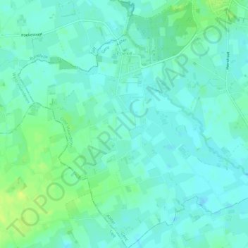
Name: Poeke topographic map, elevation, terrain.
Location: Poeke, Aalter, Gent, Oost-Vlaanderen, Vlaanderen, België (51.01646 3.42274 51.04787 3.47077)
Average elevation: 43 ft
Minimum elevation: 23 ft
Maximum elevation: 82 ft
Make a donation
Gear up for your next adventure:
As an Amazon Associate, this site earns from qualifying purchases at no extra cost to you.
Other topographic maps
Click on a map to view its topography, its elevation and its terrain.