
Make a donation
Gear up for your next adventure:
As an Amazon Associate, this site earns from qualifying purchases at no extra cost to you.
Arce topographic map
Click on the map to display elevation.
Make a donation
Gear up for your next adventure:
As an Amazon Associate, this site earns from qualifying purchases at no extra cost to you.
Arce
Arce o Puente Arce es una localidad del municipio de Piélagos (Cantabria, España). La localidad está a 40 metros de altitud sobre el nivel del mar, y a 7,5 kilómetros de la capital municipal . En el año 2022 contaba con una población de 2.859 habitantes (INE).
Make a donation
Gear up for your next adventure:
As an Amazon Associate, this site earns from qualifying purchases at no extra cost to you.
About this map
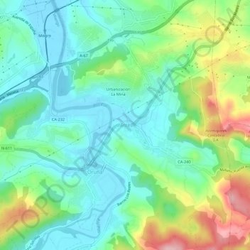
Name: Arce topographic map, elevation, terrain.
Location: Arce, Piélagos, Cantabria, 39478, España (43.38984 -3.96271 43.42984 -3.92271)
Average elevation: 194 ft
Minimum elevation: -13 ft
Maximum elevation: 646 ft
Make a donation
Gear up for your next adventure:
As an Amazon Associate, this site earns from qualifying purchases at no extra cost to you.
Other topographic maps
Click on a map to view its topography, its elevation and its terrain.