Geolocate

Petoskey topographic map

Click on the map to display elevation.

About this map

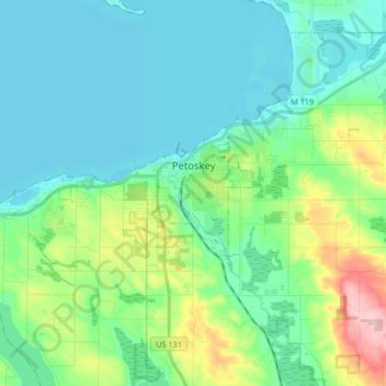
Name: Petoskey topographic map, elevation, terrain.

Location: Petoskey, Emmet County, Michigan, United States (45.34486 -85.09597 45.38477 -84.92994)

Average elevation: 732 ft

Minimum elevation: 571 ft

Maximum elevation: 1,296 ft

Emmet County trails, hiking, mountain biking, running and outdoor activities

Other topographic maps

Click on a map to view its topography, its elevation and its terrain.

Cross Village

United States > Michigan > Emmet County

Average elevation: 659 ft

Epsilon

United States > Michigan > Emmet County > Epsilon

Average elevation: 755 ft

Gear up for your next adventure:

📚USA Hiking Guide Books - Top trail guides and map books
🪑Portable Camp Table - Compact table for campsite meals
🎒Trekking Poles - Sturdy poles for balance and stability on rough terrain
👖Convertible Hiking Pants - Versatile zip-off pants for changing altitudes and temperatures
🎒Outdoor Daypacks - Lightweight backpacks designed for carrying maps and essential gear

As an Amazon Associate, this site earns from qualifying purchases at no extra cost to you.