Geolocate

Miles topographic map

Click on the map to display elevation.

About this map

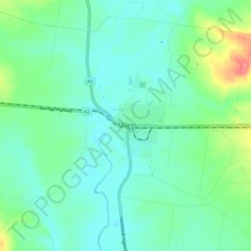
Name: Miles topographic map, elevation, terrain.

Location: Miles, Western Downs Regional, Queensland, Australia (-26.69972 150.14556 -26.61972 150.22556)

Average elevation: 1,020 ft

Minimum elevation: 961 ft

Maximum elevation: 1,211 ft

Gear up for your next adventure:

🪶Fire Starter Kit - Reliable fire starter for survival and camping
🔊Portable Camp Speaker - Music and alerts at camp
🪶LED Camping Lantern - Bright lantern for camp lighting
🗻Climbing Gear Basics - Essential gear for beginner climbers
📌Outdoor GPS Map App - Apps and devices for digital topographic navigation

As an Amazon Associate, this site earns from qualifying purchases at no extra cost to you.