Geolocate

Plattsburgh topographic map

Click on the map to display elevation.

About this map

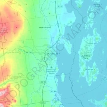
Name: Plattsburgh topographic map, elevation, terrain.

Location: Plattsburgh, Clinton County, New York, 12901, United States (44.53282 -73.61562 44.85282 -73.29562)

Average elevation: 381 ft

Minimum elevation: 85 ft

Maximum elevation: 2,087 ft

Clinton County trails, hiking, mountain biking, running and outdoor activities

Gear up for your next adventure:

🪶Camp Gear Gift Set - Perfect gift bundle for outdoor fans
🎒Day Hiking Backpack - Lightweight backpack perfect for day trips and outdoor adventures
📷Action Camera - Capture your outdoor adventures in HD
GPS Sports Watch - GPS watch for running, hiking and training
🍳Camping Cook Set - Complete cookware for outdoor meals

As an Amazon Associate, this site earns from qualifying purchases at no extra cost to you.