
Make a donation
Gear up for your next adventure:
As an Amazon Associate, this site earns from qualifying purchases at no extra cost to you.
Saint-Franc topographic map
Click on the map to display elevation.
Make a donation
Gear up for your next adventure:
As an Amazon Associate, this site earns from qualifying purchases at no extra cost to you.
Saint-Franc
Saint-Franc est une commune boisée (à 35 %), constituée de plusieurs hameaux, et comptant 725 hectares de territoire dont 245 hectares de forêts et 12 hectares de zones humides. L'altitude minimale de Saint-Franc se trouve au niveau du Guiers alors que l'altitude maximale (725m) se trouve au niveau de l'oratoire de Notre-Dame du Châtelard.
Make a donation
Gear up for your next adventure:
As an Amazon Associate, this site earns from qualifying purchases at no extra cost to you.
About this map
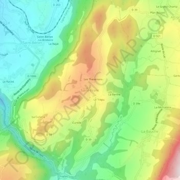
Name: Saint-Franc topographic map, elevation, terrain.
Average elevation: 1,709 ft
Minimum elevation: 892 ft
Maximum elevation: 2,910 ft
Make a donation
Gear up for your next adventure:
As an Amazon Associate, this site earns from qualifying purchases at no extra cost to you.