
Springfield topographic map
Click on the map to display elevation.
Springfield
Aside from its rivers, Springfield's second most prominent topographical feature is the city's 735-acre (297 ha) Forest Park. Forest Park lies in the southwestern corner of the city, surrounded by Springfield's attractive garden districts, Forest Park and Forest Park Heights, which feature over 600 Victorian Painted Lady mansions. Forest Park also borders Western Massachusetts' most affluent town, Longmeadow. Springfield shares borders with other well-heeled suburbs such as East Longmeadow, Wilbraham, Ludlow and the de-industrializing city of Chicopee. The small cities of Agawam and West Springfield lie less than a mile (1.6 km) from Springfield's Metro Center, across the Connecticut River.
About this map
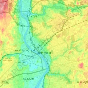
Name: Springfield topographic map, elevation, terrain.
Location: Springfield, Hampden County, Massachusetts, United States (42.06374 -72.62216 42.16222 -72.47109)
Average elevation: 164 ft
Minimum elevation: 26 ft
Maximum elevation: 377 ft
Hampden County trails, hiking, mountain biking, running and outdoor activities
Other topographic maps
Click on a map to view its topography, its elevation and its terrain.
Mittineague
United States > Massachusetts > Hampden County > West Springfield
Average elevation: 161 ft
Duckville
United States > Massachusetts > Hampden County > Palmer > Bondsville
Average elevation: 440 ft
Meadowbrook Green
United States > Massachusetts > Hampden County > Palmer > Thorndike
Average elevation: 453 ft
Palmer Green Estates
United States > Massachusetts > Hampden County > Palmer
Average elevation: 459 ft
Victory Lake Dam
United States > Massachusetts > Hampden County > Camp Spruce Hill
Average elevation: 1,040 ft