
Make a donation
Gear up for your next adventure:
As an Amazon Associate, this site earns from qualifying purchases at no extra cost to you.
Dornstadt topographic map
Click on the map to display elevation.
Make a donation
Gear up for your next adventure:
As an Amazon Associate, this site earns from qualifying purchases at no extra cost to you.
About this map
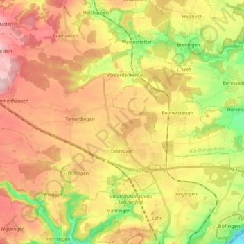
Name: Dornstadt topographic map, elevation, terrain.
Average elevation: 1,949 ft
Minimum elevation: 1,516 ft
Maximum elevation: 2,343 ft
Make a donation
Gear up for your next adventure:
As an Amazon Associate, this site earns from qualifying purchases at no extra cost to you.
Other topographic maps
Click on a map to view its topography, its elevation and its terrain.
Inselbad
Germany > Baden-Württemberg > Alb-Donau-Kreis > Munderkingen > Algershofen
Average elevation: 1,722 ft
Hinterdenkental
Germany > Baden-Württemberg > Alb-Donau-Kreis > Westerstetten
Average elevation: 1,978 ft
Make a donation
Gear up for your next adventure:
As an Amazon Associate, this site earns from qualifying purchases at no extra cost to you.