Geolocate

Berlin topographic map

Click on the map to display elevation.

About this map

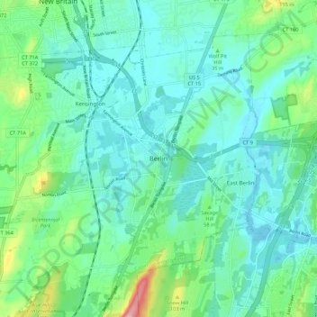
Name: Berlin topographic map, elevation, terrain.

Location: Berlin, Hartford County, Connecticut, 06037, USA (41.58149 -72.78565 41.66149 -72.70565)

Average elevation: 135 ft

Minimum elevation: 10 ft

Maximum elevation: 607 ft

Gear up for your next adventure:

🛡️Insect Repellent - Protection against bugs during outdoor activities
🪶Camping Sleeping Pad - Comfortable sleeping pad for backpacking
🪑Ultralight Camp Chairs - Portable seating for resting after a long day of mapping
📷Action Cameras - Rugged cameras to document your journeys across rugged terrain
🦶Carbon Trekking Poles - Reduce knee impact on steep descents with ultra-light poles

As an Amazon Associate, this site earns from qualifying purchases at no extra cost to you.