
Thank you for supporting this site ❤️
Make a donation
Make a donation
Gear up for your next adventure:
As an Amazon Associate, this site earns from qualifying purchases at no extra cost to you.
Bela topographic map
Click on the map to display elevation.
Thank you for supporting this site ❤️
Make a donation
Make a donation
Gear up for your next adventure:
As an Amazon Associate, this site earns from qualifying purchases at no extra cost to you.
About this map
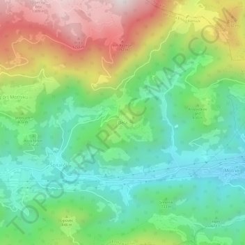
Name: Bela topographic map, elevation, terrain.
Location: Bela, Kamnik, Upravna Enota Kamnik, 1221, Slovenia (46.20334 14.84010 46.24334 14.88010)
Average elevation: 2,493 ft
Minimum elevation: 1,407 ft
Maximum elevation: 4,406 ft
Thank you for supporting this site ❤️
Make a donation
Make a donation
Gear up for your next adventure:
As an Amazon Associate, this site earns from qualifying purchases at no extra cost to you.