
Thank you for supporting this site ❤️
Make a donation
Make a donation
Gear up for your next adventure:
As an Amazon Associate, this site earns from qualifying purchases at no extra cost to you.
Bujões topographic map
Click on the map to display elevation.
Thank you for supporting this site ❤️
Make a donation
Make a donation
Gear up for your next adventure:
As an Amazon Associate, this site earns from qualifying purchases at no extra cost to you.
About this map
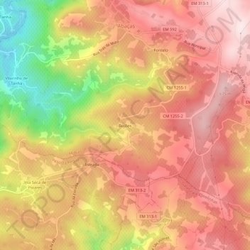
Name: Bujões topographic map, elevation, terrain.
Location: Bujões, Abaças, Vila Real, 5050-042, Portugal (41.18885 -7.71446 41.22885 -7.67446)
Average elevation: 1,699 ft
Minimum elevation: 732 ft
Maximum elevation: 2,257 ft
Thank you for supporting this site ❤️
Make a donation
Make a donation
Gear up for your next adventure:
As an Amazon Associate, this site earns from qualifying purchases at no extra cost to you.