
Thank you for supporting this site ❤️
Make a donation
Make a donation
Gear up for your next adventure:
As an Amazon Associate, this site earns from qualifying purchases at no extra cost to you.
Paraíso topographic map
Click on the map to display elevation.
Thank you for supporting this site ❤️
Make a donation
Make a donation
Gear up for your next adventure:
As an Amazon Associate, this site earns from qualifying purchases at no extra cost to you.
About this map
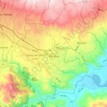
Name: Paraíso topographic map, elevation, terrain.
Location: Paraíso, Cantón Paraíso, Provincia Cartago, 30201, Costa Rica (9.80052 -83.90671 9.88052 -83.82671)
Average elevation: 4,357 ft
Minimum elevation: 3,219 ft
Maximum elevation: 5,518 ft
Thank you for supporting this site ❤️
Make a donation
Make a donation
Gear up for your next adventure:
As an Amazon Associate, this site earns from qualifying purchases at no extra cost to you.