Geolocate

Cascade topographic map

Click on the map to display elevation.

About this map

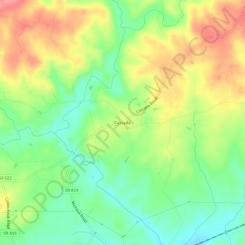
Name: Cascade topographic map, elevation, terrain.

Location: Cascade, Pittsylvania County, Virginia, 24069, United States (36.54458 -79.68975 36.58458 -79.64975)

Average elevation: 636 ft

Minimum elevation: 499 ft

Maximum elevation: 807 ft

Pittsylvania County trails, hiking, mountain biking, running and outdoor activities

Gear up for your next adventure:

🦺Reflective Outdoor Gear - Safety gear for low‑light conditions
Solar GPS Watches - Advanced multisport watches with built-in topographic maps
🛠️Backpacking Tool Kit - Essential toolkit for outdoor repairs
🌎3D Topographic Globes - Raised relief globes for a tactile understanding of geography
🎒Hydration Pack - Hands‑free water reservoir for long hikes

As an Amazon Associate, this site earns from qualifying purchases at no extra cost to you.