
Make a donation
Gear up for your next adventure:
As an Amazon Associate, this site earns from qualifying purchases at no extra cost to you.
Opgrimbie topographic map
Click on the map to display elevation.
Make a donation
Gear up for your next adventure:
As an Amazon Associate, this site earns from qualifying purchases at no extra cost to you.
Opgrimbie
Opgrimbie ligt in het Maasdal op ongeveer 45 meter hoogte, gemeten via de Tweede Algemene Waterpassing. Naar het westen toe loopt de hoogte op via de steilrand naar het Kempens Plateau, waar hoogten tot meer dan 90 meter worden bereikt. Hier bevindt zich het Koninklijk Domein van Opgrimbie, een enclave in het Nationaal Park Hoge Kempen. Tot het Nationaal Park behoort het natuurgebied De Vallei van de Kikbeek, dat zich ten zuiden van de autoweg A2 bevindt. Oorspronkelijk werd in dit gebied zilverzand gewonnen, daarna zijn de groeve en de waterloop teruggegeven aan de natuur.
Make a donation
Gear up for your next adventure:
As an Amazon Associate, this site earns from qualifying purchases at no extra cost to you.
About this map
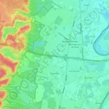
Name: Opgrimbie topographic map, elevation, terrain.
Location: Opgrimbie, Maasmechelen, Tongeren, Limburg, Vlaanderen, België (50.93289 5.59532 50.97790 5.70338)
Average elevation: 164 ft
Minimum elevation: 98 ft
Maximum elevation: 328 ft
Make a donation
Gear up for your next adventure:
As an Amazon Associate, this site earns from qualifying purchases at no extra cost to you.
Other topographic maps
Click on a map to view its topography, its elevation and its terrain.
Daalgrimbie
België > Limburg > Tongeren > Maasmechelen > Opgrimbie > Daalgrimbie
Average elevation: 144 ft