
Make a donation
Gear up for your next adventure:
As an Amazon Associate, this site earns from qualifying purchases at no extra cost to you.
Añón de Moncayo topographic map
Click on the map to display elevation.
Make a donation
Gear up for your next adventure:
As an Amazon Associate, this site earns from qualifying purchases at no extra cost to you.
About this map
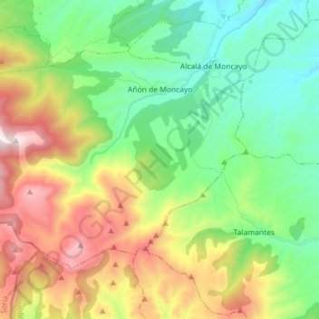
Name: Añón de Moncayo topographic map, elevation, terrain.
Average elevation: 3,474 ft
Minimum elevation: 2,083 ft
Maximum elevation: 6,076 ft
Make a donation
Gear up for your next adventure:
As an Amazon Associate, this site earns from qualifying purchases at no extra cost to you.
Other topographic maps
Click on a map to view its topography, its elevation and its terrain.
Sistema Ibérico
España > Aragón > Tarazona y el Moncayo > Tarazona
El sistema Ibérico es un sistema montañoso de altitud media ubicada en el interior de la península ibérica, en España. Algunos de sus picos más altos son el Moncayo (2315 m s. n. m.), su cumbre de mayor altitud, el monte San Lorenzo (2271 m s. n. m.), el pico de Urbión (2228 m s. n. m.), el…
Average elevation: 6,253 ft
Make a donation
Gear up for your next adventure:
As an Amazon Associate, this site earns from qualifying purchases at no extra cost to you.