
Make a donation
Gear up for your next adventure:
As an Amazon Associate, this site earns from qualifying purchases at no extra cost to you.
Belén Gualcho topographic map
Click on the map to display elevation.
Make a donation
Gear up for your next adventure:
As an Amazon Associate, this site earns from qualifying purchases at no extra cost to you.
Belén Gualcho
Belen Gualcho se encuentra a una altitud de 1641 m s. n. m., por lo que posee un Clima templado subhúmedo, que de acuerdo con la clasificación climática de Köppen, es de verano suave (Cwb). la altitud provoca que las tardes sean frías, sobre todo en meses de invierno junio/julio, cuando la temperatura se sitúa sobre los 10 °C. El período más caluroso y soleado del año son los meses de diciembre y marzo, cuando la temperatura promedio oscila alrededor de los 20 °C durante el día. La temperatura máxima es de 24 °C.
Make a donation
Gear up for your next adventure:
As an Amazon Associate, this site earns from qualifying purchases at no extra cost to you.
About this map
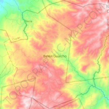
Name: Belén Gualcho topographic map, elevation, terrain.
Location: Belén Gualcho, Ocotepeque, Honduras (14.41310 -88.85609 14.54956 -88.71447)
Average elevation: 5,791 ft
Minimum elevation: 3,176 ft
Maximum elevation: 7,949 ft
Make a donation
Gear up for your next adventure:
As an Amazon Associate, this site earns from qualifying purchases at no extra cost to you.
Other topographic maps
Click on a map to view its topography, its elevation and its terrain.