
Make a donation
Gear up for your next adventure:
As an Amazon Associate, this site earns from qualifying purchases at no extra cost to you.
Sandia Mountain Wilderness topographic map
Click on the map to display elevation.
Make a donation
Gear up for your next adventure:
As an Amazon Associate, this site earns from qualifying purchases at no extra cost to you.
Sandia Mountain Wilderness
Some of the most common animals seen in the Sandia Wilderness are mule deer, black bears, raccoons, bobcats, and various species of squirrel. There are also many birds of prey that live and migrate within the Sandia Mountain Wilderness including golden eagles and various species of hawks. Other birds such as roadrunners, Steller's Jays, ravens, and canyon wrens can also be found on in the mountains. The upper parts of the Sandia Mountains have a lot of tree cover made up mostly of firs and spruce trees, with ponderosas and conifers inhabiting the middle elevations.
Make a donation
Gear up for your next adventure:
As an Amazon Associate, this site earns from qualifying purchases at no extra cost to you.
About this map
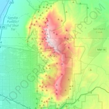
Name: Sandia Mountain Wilderness topographic map, elevation, terrain.
Average elevation: 6,729 ft
Minimum elevation: 5,023 ft
Maximum elevation: 10,646 ft
Bernalillo County trails, hiking, mountain biking, running and outdoor activities
Make a donation
Gear up for your next adventure:
As an Amazon Associate, this site earns from qualifying purchases at no extra cost to you.