
Thank you for supporting this site ❤️
Make a donation
Make a donation
Gear up for your next adventure:
As an Amazon Associate, this site earns from qualifying purchases at no extra cost to you.
Sardis topographic map
Click on the map to display elevation.
Thank you for supporting this site ❤️
Make a donation
Make a donation
Gear up for your next adventure:
As an Amazon Associate, this site earns from qualifying purchases at no extra cost to you.
About this map
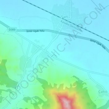
Name: Sardis topographic map, elevation, terrain.
Location: Sardis, Sart, Salihli, Manisa, Aegean Region, Turkey (38.48723 28.03908 38.48941 28.04174)
Average elevation: 440 ft
Minimum elevation: 285 ft
Maximum elevation: 1,309 ft
Thank you for supporting this site ❤️
Make a donation
Make a donation
Gear up for your next adventure:
As an Amazon Associate, this site earns from qualifying purchases at no extra cost to you.