
Make a donation
Gear up for your next adventure:
As an Amazon Associate, this site earns from qualifying purchases at no extra cost to you.
Mount Yamantau topographic map
Click on the map to display elevation.
Make a donation
Gear up for your next adventure:
As an Amazon Associate, this site earns from qualifying purchases at no extra cost to you.
Mount Yamantau
Up to 1,000–1,100 m elevation, the mountain slope is covered with mixed forest, in some places with driftwood, occasional alpine meadows and rocky outcrops. Above 1,100 m elevation, there are no trees or bushes, and instead rock streams of various sizes, with grass, flowers and moss start to appear.
Make a donation
Gear up for your next adventure:
As an Amazon Associate, this site earns from qualifying purchases at no extra cost to you.
About this map
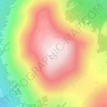
Name: Mount Yamantau topographic map, elevation, terrain.
Average elevation: 4,377 ft
Minimum elevation: 3,127 ft
Maximum elevation: 5,374 ft
Make a donation
Gear up for your next adventure:
As an Amazon Associate, this site earns from qualifying purchases at no extra cost to you.
Other topographic maps
Click on a map to view its topography, its elevation and its terrain.