Geolocate

Kemmerer topographic map

Click on the map to display elevation.

About this map

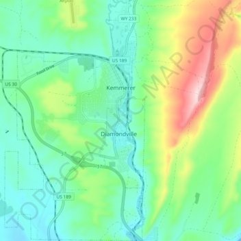
Name: Kemmerer topographic map, elevation, terrain.

Location: Kemmerer, Lincoln County, Wyoming, United States (41.74896 -110.58203 41.81737 -110.52903)

Average elevation: 7,123 ft

Minimum elevation: 6,818 ft

Maximum elevation: 7,858 ft

Other topographic maps

Click on a map to view its topography, its elevation and its terrain.

Freedom

United States > Wyoming > Lincoln County

Average elevation: 5,820 ft

Salt River Range

United States > Wyoming > Lincoln County

Average elevation: 7,887 ft

Wyoming Peak

United States > Wyoming > Lincoln County

Average elevation: 10,197 ft

Wyoming Range

United States > Wyoming > Lincoln County

Average elevation: 7,733 ft

Gear up for your next adventure:

🧺Microfiber Travel Towels - Compact and fast-drying towels for trail use
💧Water Filtration Bottles - Safely drink from streams and lakes while exploring
🌡️Handheld Weather Meters - Measure wind, temp, and pressure for safe mountain travel
🧦Merino Wool Socks - Moisture-wicking, blister-preventing socks for long treks
🧢Outdoor Hiking Hat - Sun protection hat for outdoor explorers

As an Amazon Associate, this site earns from qualifying purchases at no extra cost to you.