Geolocate

Ackworth topographic map

Click on the map to display elevation.

About this map

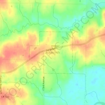
Name: Ackworth topographic map, elevation, terrain.

Location: Ackworth, Warren County, Iowa, United States (41.36058 -93.48145 41.37143 -93.46665)

Average elevation: 856 ft

Minimum elevation: 768 ft

Maximum elevation: 942 ft

Warren County trails, hiking, mountain biking, running and outdoor activities

Other topographic maps

Click on a map to view its topography, its elevation and its terrain.

Ackworth

United States > Iowa > Warren County > Ackworth

Average elevation: 856 ft

Spring Hill

United States > Iowa > Warren County > Spring Hill

Average elevation: 869 ft

Gear up for your next adventure:

🎒Trekking Poles - Sturdy poles for balance and stability on rough terrain
🚗GPS Dash Cams - Record your scenic drives through mountain passes and canyons
📻Weather Alert Radios - Stay informed of storm risks while off-the-grid
🪶Thermal Camp Blanket - Extra warmth for cold nights
🧯Emergency Survival Kit - All‑in‑one survival essentials for the backcountry

As an Amazon Associate, this site earns from qualifying purchases at no extra cost to you.