Geolocate

Spring Hill topographic map

Click on the map to display elevation.

About this map

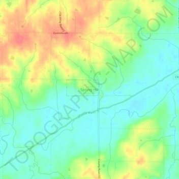
Name: Spring Hill topographic map, elevation, terrain.

Location: Spring Hill, Warren County, Iowa, United States (41.39176 -93.66799 41.43176 -93.62799)

Average elevation: 869 ft

Minimum elevation: 791 ft

Maximum elevation: 981 ft

Warren County trails, hiking, mountain biking, running and outdoor activities

Gear up for your next adventure:

🔋Solar Power Banks - Keep your GPS and phone charged in remote wilderness areas
🎒Trekking Poles - Sturdy poles for balance and stability on rough terrain
🧯Emergency Survival Kit - All‑in‑one survival essentials for the backcountry
🔌USB Car Charger - Car charger for on‑the‑go power needs
🕶️GPS Smartphone Mount - Secure mount for phone navigation

As an Amazon Associate, this site earns from qualifying purchases at no extra cost to you.