
Regina topographic map
Click on the map to display elevation.
About this map
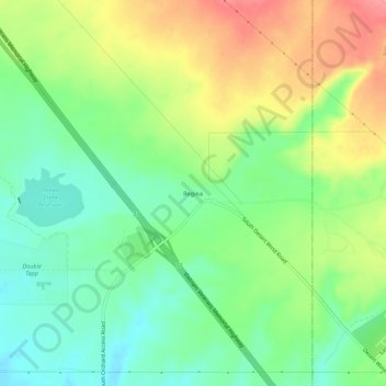
Name: Regina topographic map, elevation, terrain.
Location: Regina, Ada County, Idaho, United States (43.37017 -116.01205 43.41017 -115.97205)
Average elevation: 3,392 ft
Minimum elevation: 3,274 ft
Maximum elevation: 3,566 ft
Ada County trails, hiking, mountain biking, running and outdoor activities
Other topographic maps
Click on a map to view its topography, its elevation and its terrain.
Boise
United States > Idaho > Ada County
Boise (/ˈbɔɪziː/, BOYZ-ee; locally /ˈbɔɪsiː/ (listen), BOYSS-ee) is the capital and most populous city of the U.S. state of Idaho and is the county seat of Ada County. On the Boise River in southwestern Idaho, it is 41 miles (66 km) east of the Oregon border and 110 miles (177 km) north of the Nevada…
Average elevation: 3,182 ft
Star
United States > Idaho > Ada County
Star is located at 43°41′39″N 116°29′25″W / 43.69417°N 116.49028°W / 43.69417; -116.49028 (43.694084, -116.490225), at an elevation of 2,470 feet (753 m) above sea level. According to the United States Census Bureau, the city has a total area of 5.86 square miles (15.18 km2), of which 5.82…
Average elevation: 2,510 ft
Garden City
United States > Idaho > Ada County
Garden City is located at 43°38′44″N 116°15′58″W / 43.64556°N 116.26611°W / 43.64556; -116.26611 (43.645561, -116.266132), at an elevation of 2674 feet (815 m) above sea level.
Average elevation: 2,795 ft
Boise
United States > Idaho > Ada County
Boise (/ˈbɔɪziː/, BOYZ-ee locally /ˈbɔɪsiː/ (listen), BOYSS-ee) is the capital and most populous city of the U.S. state of Idaho and is the county seat of Ada County. On the Boise River in southwestern Idaho, it is 41 miles (66 km) east of the Oregon border and 110 miles (177 km) north of the Nevada…
Average elevation: 3,182 ft
Boise
United States > Idaho > Ada County
Boise (locally /ˈbɔɪsi/ BOY-see) is the capital and most populous city of the U.S. state of Idaho. The population was 235,685 at the 2020 census. The Boise metropolitan area, also known as the Treasure Valley, includes five counties with an estimated population of 846,000, the most populous metropolitan…
Average elevation: 3,182 ft
Star
United States > Idaho > Ada County
Star is located at 43°41′39″N 116°29′25″W / 43.69417°N 116.49028°W / 43.69417; -116.49028 (43.694084, -116.490225), at an elevation of 2,470 feet (753 m) above sea level. According to the United States Census Bureau, the city has a total area of 5.86 square miles (15.18 km2), of which 5.82…
Average elevation: 2,510 ft
Boise
United States > Idaho > Ada County
Boise (locally /ˈbɔɪsi/ BOY-see) is the capital and most populous city of the U.S. state of Idaho. The population was 235,685 at the 2020 census. The Boise metropolitan area, also known as the Treasure Valley, includes five counties with an estimated population of 846,000, the most populous metropolitan…
Average elevation: 3,182 ft
Boise
United States > Idaho > Ada County
Located on the Boise River in southwestern Idaho, it is 41 miles (66 km) east of the Oregon border and 110 miles (177 km) north of the Nevada border. Downtown Boise's elevation is 2,704 feet (824 m) above sea level. Originally established as a military outpost in 1863 during the gold rush era, Boise rapidly…
Average elevation: 3,182 ft
Boise
United States > Idaho > Ada County
Boise (locally /ˈbɔɪsi/ BOY-see) is the capital and most populous city of the U.S. state of Idaho. The population was 235,685 at the 2020 census. The Boise metropolitan area, also known as the Treasure Valley, includes five counties with an estimated population of 846,000, the most populous metropolitan…
Average elevation: 3,182 ft