
Make a donation
Gear up for your next adventure:
As an Amazon Associate, this site earns from qualifying purchases at no extra cost to you.
Eisgraben topographic map
Click on the map to display elevation.
Make a donation
Gear up for your next adventure:
As an Amazon Associate, this site earns from qualifying purchases at no extra cost to you.
About this map
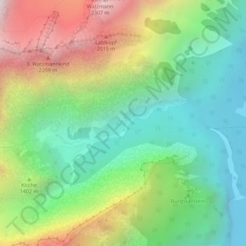
Name: Eisgraben topographic map, elevation, terrain.
Average elevation: 4,134 ft
Minimum elevation: 1,982 ft
Maximum elevation: 7,858 ft
Make a donation
Gear up for your next adventure:
As an Amazon Associate, this site earns from qualifying purchases at no extra cost to you.
Other topographic maps
Click on a map to view its topography, its elevation and its terrain.
Duft
Deutschland > Bayern > Landkreis Berchtesgadener Land > Schönau am Königssee
Average elevation: 2,638 ft
3. Watzmannkind
Deutschland > Bayern > Landkreis Berchtesgadener Land > Schönau am Königssee
Average elevation: 5,797 ft
Jenner
Deutschland > Bayern > Landkreis Berchtesgadener Land > Schönau am Königssee
Average elevation: 4,570 ft
Pfaffenkegel
Deutschland > Bayern > Landkreis Berchtesgadener Land > Schönau am Königssee
Average elevation: 5,617 ft
Make a donation
Gear up for your next adventure:
As an Amazon Associate, this site earns from qualifying purchases at no extra cost to you.
Grünstein
Deutschland > Bayern > Landkreis Berchtesgadener Land > Schönau am Königssee
Der bequemste Weg führt vom Parkplatz Hammerstiel in der Oberschönau vorbei an der bewirtschafteten Grünsteinhütte auf 1220 m Höhe zum Gipfel. Ein weiterer Weg führt steiler und etwas alpiner vom Königssee entlang der Kunsteis-Rodelbahn weiter zur Grünsteinhütte und vereinigt sich dann mit dem ersten…
Average elevation: 2,963 ft
Röthbachfall
Deutschland > Bayern > Landkreis Berchtesgadener Land > Schönau am Königssee
Der Röthbach stürzt südlich des Obersees unterhalb der Röth über die Röthwand in zwei Hauptstufen beinahe senkrecht nach unten. Die Höhe wird im Allgemeinen mit ca. 470 Meter angegeben und bezieht damit, wie auch sonst oft gehandhabt, den nachfolgenden Sturzbachabschnitt mit ein. Aus der…
Average elevation: 4,678 ft
Jenner
Deutschland > Bayern > Landkreis Berchtesgadener Land > Schönau am Königssee
Average elevation: 4,570 ft