Geolocate

Dewas topographic map

Click on the map to display elevation.

About this map

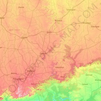
Name: Dewas topographic map, elevation, terrain.

Location: Dewas, Madhya Pradesh, India (22.30000 75.46667 23.70000 76.86667)

Average elevation: 1,526 ft

Minimum elevation: 577 ft

Maximum elevation: 2,772 ft

Gear up for your next adventure:

💧Water Purification System - Clean water on the trail with reliable purifiers
📦Gear Storage Bags - Organize and protect outdoor equipment
🔋Solar Power Banks - Keep your GPS and phone charged in remote wilderness areas
🧴Hand Sanitizer - Keep hands clean while hiking
🪑Ultralight Camp Chairs - Portable seating for resting after a long day of mapping

As an Amazon Associate, this site earns from qualifying purchases at no extra cost to you.