
Thank you for supporting this site ❤️
Make a donation
Make a donation
Gear up for your next adventure:
As an Amazon Associate, this site earns from qualifying purchases at no extra cost to you.
Paspels topographic map
Click on the map to display elevation.
Thank you for supporting this site ❤️
Make a donation
Make a donation
Gear up for your next adventure:
As an Amazon Associate, this site earns from qualifying purchases at no extra cost to you.
About this map
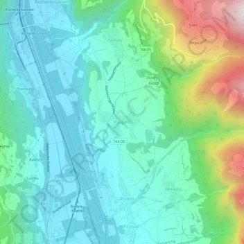
Name: Paspels topographic map, elevation, terrain.
Location: Paspels, Domleschg, Viamala, Grisons, 7417, Suisse (46.72867 9.42409 46.76867 9.46409)
Average elevation: 2,894 ft
Minimum elevation: 2,001 ft
Maximum elevation: 5,755 ft
Thank you for supporting this site ❤️
Make a donation
Make a donation
Gear up for your next adventure:
As an Amazon Associate, this site earns from qualifying purchases at no extra cost to you.